|
||||


USING gmap15 FOR ROUTE VIEWING, CUE SHEETS and CUE SHEET EDITING | ||
Randonneurs OntarioI ) Objective The goal of this page is to introduce you to gmap components and give a brief tutorial on cue sheet embedding in GPS files. The objective of gmap15 is to combine GPS technology and paper, turn-by-turn cue sheets. Reviewing and editing of cue sheets should be easier while the cues should be more accurate. Gmap15 uses the notes field stored in tcx files or the rte fields stored in gpx files to supply turn by turn cue sheets. Browser limitations and security. I work with Firefox on Linux and test with Firefox and Safari on Mac OS-X and Firefox on Windows XP. Local file access uses FileReader and works with Firefox and is supposed to work in Internet Explorer 10.0 and Safari 6.0 and later. FileReader does not work in older versions of Internet Explorer or Safari. The entire app is written in Javascript and executes in the browser. Security restrictions in the design of Javascript prevent access to the local hard drive in a standard fashion. To get edited files out I use a text window and ask that you copy and paste the entire window contents to a text editor and save the file. When a good mechanism for local file storage becomes available for browsers, I hope to change this. II ) Overview When gmap opens it should present a screen much like that shown below. The upper part of the display is a Google Map, a free service offered by Google. The lower left is a profile chart that shows a simplified elevation versus distance graph. The lower right is a statistics table which shows details of each track that was loaded. The map controls are in the upper right corner. The very top controls are the boxes Map Satellite which are provided by Google. Descending down the right side of the page there is a control for each track found in the given file. The number of these track controls will depend on how many tracks were read. To the left of MAP there is a box marked FULL. It is the control which hides the profile and statistics windows allowing a full screen view of the map. On the top left there is a box labeled "File" from which a menu should drop down on mouseover.
Open gmap in a different tab by right clicking on this link and experiment with the controls in a live window. This is a tcx file. To see more files, there is a table of work in progress at the bottom of the page. III )Inserting 1 cue
Insert a cue by zooming in to the location where you want the cue. Right click on the black track line at the spot you want the cue.
The cursor changes from a waving hand to a pointing finger when this feature is active. A green balloon should appear on the track and a small edit window will open. It should look like the image at right. IV ) Editing and deleting cues Right clicking on an existing cue re-opens the edit balloon. Make any changes you want then click Save. Delete a cue by openning the edit window with a right click and clicking on Delete. Cancel and "Close window" both close the window with no changes. There is no Undo operation. If undo is really important to you please let me know and it may be included in a future version of gmap. To reset everything, reload the page. That can easily be done with Reload or Back and then Forward. This is also a warning that any edits can be lost instantly by navigating away from the gmap page. This is the same behaviour as in Google Maps. V )Google Directions Service The Google Maps that you may be familiar with is a Google web site. The components used to make up Google's site have been made available for purchase or in a restricted form for free. We use the free service whic comes with 2 restrictions. 1) only 7 waypoints can be applied and 2) only 2500 requests per day are allowed. In addition, Google's terms of use specify that if we render te turn dirsctions ourselves, then we must attach Googles copyright notice. Our cue sheet is the rendering of the directions and you will find a Google copyright appended at the bottom of each cue sheet if Googles Directions Service was used. Here is how to use Google Directions Service on one of my tracks. Right click this link and open in a new tab to try.
VI ) Rules for cues from the Google Directions Service
Gmap always applys the following rules when incorporating cues from Google Directions Service. If a a cue is rejected, an alert window is openned describing each rejection. VII ) Importing gpx files GPX files are read in 3 sections: waypoints, tracks and routes. Waypoints are indexed by associating each point with a track point based on nearest approach. At present, only waypoints that have control in either thier name or desc field are inserted. All tracks are tested since waypoints do not inherently have an association with any track. On loop routes this will be unambiguous but on out and back routes the closest track point may be in the wrong direction. Check on what happens. The route points are then indexed in sequence which should be unambiguous since they should occur in the sequence they will be passed. If a route point collides (closer than 10 meters) with one of the previously inserted waypoints, the route point is discharded. VIII ) Getting a track file Use a gps recorded track from last years ride. Go and ride the route with gps recording. Drive the route. After each ride I try to remember to save the recorded track. Often some part of the track will be useful in making a different route. See far down on this page for track editing using gmap. I think that breaking the route into segments at controls makes my visualization of the route easier. The track control switches both the track and any cues associated with that segment on and off. Tracks are 50 to 150km long and that is a reasonnable size to inspect at once. I break the route file by switching my Garmin GPSMap 60Cx off and then on again at each control. This makes tracks with names like ACTIVETRACK001 ACTIVETRACK002 etc.. Gmap however does not impose a requirement that tracks be broken or that track breaks are coincident with controls. Many of my old files have no breaks or breaks in the wrong places so not having a rule here lets me use old data with less work. It is however, very difficult to inspect out and back routes when both are turned on so I am in the process of breaking my files at controls. IX ) Conventions in gpx files
X ) Track trimming, splitting and merging - a recent addition to gmap I have a collection of gpx files and need a method of easily trimming off bits of the file and cutting tracks into sections. I use a few programs in combination, none of which is exactly right. gmap is mostly being made for me to make and check cue sheets easily. Here I will demonstrate trim, split and merge additions to gmap using an archive file from a ride in 2005. The live link will show a bare track with no cues. There is extra stuff on the track because I turned the gps on at home and may have forgotten to turn it off later. Also I rode a few bonus kilometers that I would like to remove. 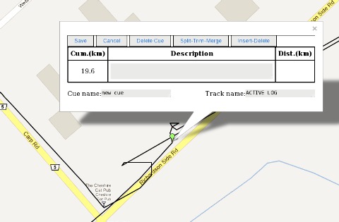
Start with trim. Zoom in on the start location, the Cheshire Cat pub which is at the corner of the route near Kanata and insert a cue on the start of the ride. The screen should show an edit menu in the ballon which has a split-trim-merge second from the right at the top. Notice that the distance shows 19.6km which is the distance from my house. Mouse over the STM menu and choose trim from the drop down list. The lead in track should disappear and the stats window should update to show about 20km removed from the track. You can now insert a cue that says Control some where and should see a distance of 0.0. Mouseover the return squiggle and right click again then trim again. The stats window and profile should upate to show that we have removed about 40km from the track. 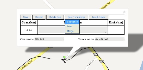
Split can be demonstrated at Calabogie the first control. Select a point before the wool ball on the route and choose "Split Track". The track is split and the temporary balloon removed. Use Trim to remove the wool ball from the outbound tracks and then add cues. Split trim merge can be demonstrated at Eganville. In 2005 I made an error and left the control going in the wrong direction. After a short distance down the road I turned around and continued on the route. This left a hair-pin in the track which I want to remove. In addition we now use a different location as a control. 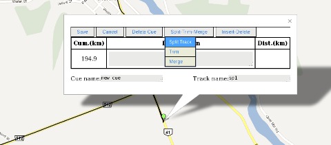
Choose the very end of the hair pin as shown at right and then choose "Split Track". This split provides 2 track ends which can now be used by Trim which always removes track to the nearest end. Trim the part on CR-512 and then trim the part on ON-41 exactly at the intersection. Trim inserts a track point at the location of the trim so the intersection can be marked exactly. The extraneous distance has been removed by 3 mouse clicks but there is a gap on the route. The distance across the gap is included in the total but the clear area indicates the begining of a new track.
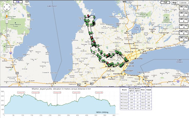
XI ) Work in progress Gmap and the cue sheets that it generates are a work in progress. Here is a look at what a selected set of gps files presently looks like.
|
||||||||||||||||||||||||||||||||||||||||
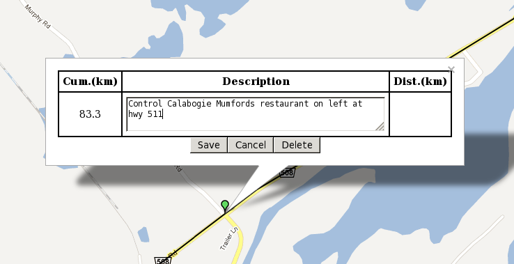 The distance from start of the track is visible at the left and if there is another cue after this, the distance to go
will be in the box at right. Enter the text that should appear in the cue and click save. If this is a control use the word
control in the description. The balloon colour will be changed to red and it will always appear on top of any other cue balloons. The
text in the cue is activated by a mouse over so a series of cues can be inspected quickly by scanning with the mouse.
The distance from start of the track is visible at the left and if there is another cue after this, the distance to go
will be in the box at right. Enter the text that should appear in the cue and click save. If this is a control use the word
control in the description. The balloon colour will be changed to red and it will always appear on top of any other cue balloons. The
text in the cue is activated by a mouse over so a series of cues can be inspected quickly by scanning with the mouse.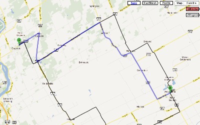 Right click on "1Winchester" over at the upper right.
The name will be given a red background
colour and a request will made for a route from the track start to the track end. You should have a screen like the
image at right if you try this with the above link.
Right click on "1Winchester" over at the upper right.
The name will be given a red background
colour and a request will made for a route from the track start to the track end. You should have a screen like the
image at right if you try this with the above link.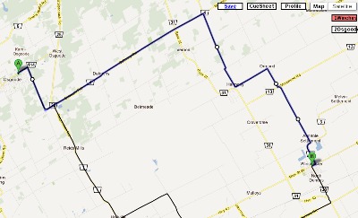 After some dragging of the route we have the blue route matching
the black track line. Right click "1Wincester" again to insert the new route points into the cue sheet.
The cue sheet should now have 13 instructions.
After some dragging of the route we have the blue route matching
the black track line. Right click "1Wincester" again to insert the new route points into the cue sheet.
The cue sheet should now have 13 instructions.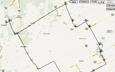 If you are following these instructions,
your map should look something like
the image at right. The green balloons appear where a cue is needed. There are as many balloons as there will be lines
on the cue sheet. Click on "File" -> "Create CueSheet" now in your trial tab/window and you should get a prototype of a cue sheet for
the 31km of this track.
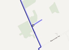
If you are following these instructions,
your map should look something like
the image at right. The green balloons appear where a cue is needed. There are as many balloons as there will be lines
on the cue sheet. Click on "File" -> "Create CueSheet" now in your trial tab/window and you should get a prototype of a cue sheet for
the 31km of this track.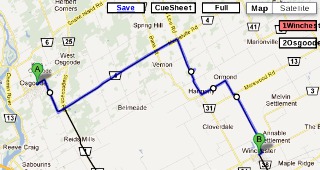
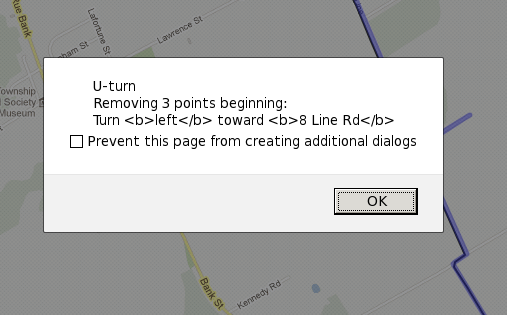 What if we do not remove the U-Turn? It will get removed by the 100 meter off track rule anyway. But
what happens when the other rules are applied? Applying the duplicate cue rule removes the second cue back on route.
So what is left? The original left turn off-route showing a distance to go to the next on-route cue. Following the cue
will lead you to visit a farmer at the end of a dead end road and a few bonus kilometers.
Gmap shows an alert like that on the right each time it removes a U-Turn.
What if we do not remove the U-Turn? It will get removed by the 100 meter off track rule anyway. But
what happens when the other rules are applied? Applying the duplicate cue rule removes the second cue back on route.
So what is left? The original left turn off-route showing a distance to go to the next on-route cue. Following the cue
will lead you to visit a farmer at the end of a dead end road and a few bonus kilometers.
Gmap shows an alert like that on the right each time it removes a U-Turn.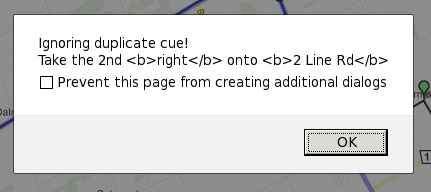 Duplicate cues are easy to generate and make annoying zero length legs on the cue sheet. For example, I like to add
key points by hand such as restaurants and controls which I can easily see on the GPS track. These cues I do not want over written
so when gmap imports a set of cues from Google Directions Service it discards new points if they are within 10 meters
of an existing cue. This also helps if you use the service more than once since there may be an overlap at the
beginning or end of the segment. An example of a gmap alert that it is ignoring a duplicate is shown at right.
Duplicate cues are easy to generate and make annoying zero length legs on the cue sheet. For example, I like to add
key points by hand such as restaurants and controls which I can easily see on the GPS track. These cues I do not want over written
so when gmap imports a set of cues from Google Directions Service it discards new points if they are within 10 meters
of an existing cue. This also helps if you use the service more than once since there may be an overlap at the
beginning or end of the segment. An example of a gmap alert that it is ignoring a duplicate is shown at right.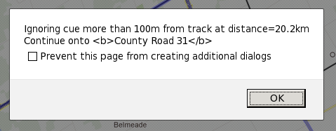 Cues that are more than 100 meters from the track are discarded. This is often a warning that some thing is wrong with the route.
Gmap displays an alert message similar to that shown at right. It includes the distance from the start of the ride
so that the area can be better inspected. Some times it is an indication that the map set is out of date and the
road has been moved. Often it indicates that there was an error in forcing the route to match the track and
it is advisable to read the cues around the given distance carefully.
Cues that are more than 100 meters from the track are discarded. This is often a warning that some thing is wrong with the route.
Gmap displays an alert message similar to that shown at right. It includes the distance from the start of the ride
so that the area can be better inspected. Some times it is an indication that the map set is out of date and the
road has been moved. Often it indicates that there was an error in forcing the route to match the track and
it is advisable to read the cues around the given distance carefully.
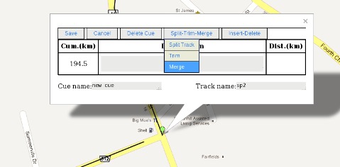 Merge joins the ends together and forms a single track with the same name as the arrival track.
|